
Italy Map Guide: Regions, Cities, and Tourist Locations Overview
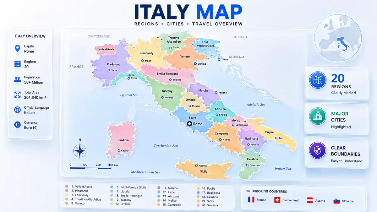
An Italy map is a geographical representation showing the country’s 20 regions, major cities, mountain ranges, rivers, and surrounding seas. Italy sits in Southern Europe as a boot-shaped peninsula extending into the Mediterranean, bordered by France, Switzerland, Austria, and Slovenia, with Sicily and Sardinia as its two major islands.
Italy Map at a Glance
| Attribute | Detail |
| Coordinates | 35°N–47°N, 6°E–19°E |
| Total area | 301,340 km² (116,350 sq mi) |
| Population | Approximately 58.9 million |
| Capital | Rome |
| Regions | 20 (5 autonomous) |
| Highest point | Mont Blanc, 4,810 m |
| Longest river | Po River, 652 km |
| Land borders | France, Switzerland, Austria, Slovenia |
| Enclave states | San Marino, Vatican City |
| Coastline | Approximately 7,600 km |
For zoom-level detail down to individual streets, an interactive digital map complements this static reference well, especially when planning specific routes or locating smaller towns not shown here.
How to Identify Any Italian City on a Map in 30 Seconds
- Find the coastline first – most major cities sit on or near it: Rome near the Tyrrhenian, Venice and Bari on the Adriatic, Naples on the Bay of Naples.
- Locate the Po Valley – a city on the flat northern plain is likely Milan, Turin, or Bologna.
- Check for island placement – Palermo and Catania sit on Sicily; Cagliari sits on Sardinia.
- Use the boot’s anatomy – cities near the “heel” belong to Puglia, cities near the “toe” belong to Calabria, and cities in the center-west cluster around Rome and Florence.
Common Mistakes When Reading Italy Maps
- Confusing map distance with travel time – mountainous terrain in the Apennines often makes real travel time longer than straight-line distance suggests.
- Mistaking a province border for a regional border – political maps color-code the 20 regions, while provinces appear only as thin internal lines.
- Misjudging island distance – Sicily and Sardinia often appear in inset boxes, which distorts how far they actually sit from the mainland.
- Assuming Trentino-Alto Adige is culturally uniform with the rest of the country, when it has a distinct German-speaking population near the Austrian border.
Italy Political Map: Regions Explained
Political map of Italy and its major cities, islands, and surrounding countries and seas.
Italy’s political map divides the country into 20 regions, each with its own capital and provincial subdivisions.
| Zone | Regions | Feature |
| North | Lombardy, Piedmont, Veneto, Emilia-Romagna, Liguria, Friuli-Venezia Giulia, Trentino-Alto Adige, Valle d’Aosta | Alps, Po Valley, industrial core |
| Center | Lazio, Tuscany, Umbria, Marche, Abruzzo | Apennine hills, capital region |
| South | Campania, Puglia, Calabria, Basilicata, Molise | Coastal plains, volcanic zones |
| Islands | Sicily, Sardinia | Mediterranean island terrain |
Read More: Italy Map
Five regions hold special autonomous status – Sicily, Sardinia, Friuli-Venezia Giulia, Trentino-Alto Adige, and Valle d’Aosta – with greater control over local taxation and administration due to island geography or linguistic minorities such as the German-speaking population in South Tyrol.
Map of Italy with Cities
| City | Region | Role |
| Rome | Lazio | National capital |
| Milan | Lombardy | Finance, fashion |
| Naples | Campania | Southern port |
| Turin | Piedmont | Automotive, industry |
| Palermo | Sicily | Largest city on the island |
| Bologna | Emilia-Romagna | University, food |
| Florence | Tuscany | Renaissance art |
| Venice | Veneto | Canal city |
| Bari | Puglia | Adriatic port |
| Genoa | Liguria | Maritime port |
Italy Physical Map: Terrain Overview
Italy physical map
Nearly 40% of Italy is mountainous. The Alps form the northern border, spanning about 1,000 km and reaching Mont Blanc at 4,810 meters, the highest point in the European Union. The Apennine Mountains run roughly 1,350 km down the peninsula’s spine, peaking at Gran Sasso d’Italia (2,912 m), before continuing into Sicily, where Mount Etna (3,329 m) rises as Europe’s largest active volcano. Near Naples, Mount Vesuvius (1,281 m) marks another key volcanic landmark, alongside Stromboli (926 m), an active volcanic island northeast of Sicily. Between the two ranges sits the Po Valley, Italy’s largest flat, fertile plain.
| Feature | Length/Size | Location |
| Po River | 652 km (longest) | Alps to Adriatic Sea |
| Adige River | 410 km | Northeast Italy |
| Tiber River | 405 km | Through Rome |
| Arno River | 241 km | Through Florence, Pisa |
| Lake Garda | Largest lake by area | Northern Italy |
| Lake Como | Known for lakeside villas | Lombardy |
Read More: Italy Map
Surrounding seas include the Tyrrhenian to the west, the Adriatic to the east, the Ionian to the south, and the Ligurian to the northwest – all connected to the broader Mediterranean.
Italy’s Location Map in Europe
Italy sits between latitude 35°N and 47°N and longitude 6°E and 19°E in Southern Europe, ranking as the tenth-largest country in Europe by area. As a founding EU member and part of the Schengen Area, it borders four countries directly – France, Switzerland, Austria, and Slovenia – while San Marino and Vatican City exist as sovereign enclaves entirely within its territory.
Transport Map of Italy: How the Country Connects
The Autostrada A1, nicknamed the “Autostrada del Sole” (Sun Motorway), is Italy’s longest highway at roughly 760 km, linking Milan, Bologna, Florence, Rome, and Naples along the same corridor used by the high-speed Frecciarossa rail line. Major international airports – Rome Fiumicino, Milan Malpensa, and Venice Marco Polo – anchor air travel at each end of this corridor.
| Route | Distance | Fastest Train Time |
| Rome → Milan | ~477 km | ~3 hours |
| Rome → Naples | ~230 km | ~1 hour 10 minutes |
| Milan → Venice | ~245 km | ~2 hours |
As a rule of thumb, expect roughly 200–250 km per hour of high-speed rail travel along the flat Po Valley and A1 corridor. Cross-mountain or island routes – reaching interior Calabria or crossing to Sicily – take considerably longer despite shorter map distances, since trains slow through Apennine tunnels and ferries replace rail links at the Strait of Messina.
Italy Map Formats: Political, Physical, and Blank
Italy maps are typically available in three formats depending on the use case:
- Labeled political map – shows all 20 regions, capitals, and major cities, ideal for general reference.
- Blank/outline map – shows only borders with no labels, commonly used for geography practice.
- Physical/terrain map – shows elevation, mountains, and rivers without political boundaries.
Italy Tourist Map: Regional Circuits
- Golden Triangle: Rome, Florence, Venice
- Amalfi Coast cluster: Naples, Sorrento, Positano, Capri
- Ligurian coast: Cinque Terre’s five clifftop villages
- Alpine cluster: The Dolomites, including resorts like Cortina d’Ampezzo
- Sicily cluster: Palermo, Taormina, Mount Etna
North vs. South Italy Map Differences
| Feature | Northern Italy | Southern Italy |
| Economy | Industrial, financial hub | Agriculture, growing tourism |
| Climate | Continental, colder winters | Mediterranean, hot summers |
| Major cities | Milan, Turin, Venice | Naples, Bari, Palermo |
| Cost of living | Highest | Generally lowest |
| Terrain | Alps, Po Valley | Apennines, coastal plains, volcanic zones |
| Language | Standard Italian dominant | Strong dialects (Neapolitan, Sicilian) |
Italy Size Comparison
| Country/Region | Area | Comparison to Italy |
| United Kingdom | ~243,600 km² | Italy is ~24% larger |
| Arizona, USA | ~294,312 km² | Italy is ~2% larger |
| Germany | ~357,580 km² | Germany is ~19% larger |
| Metropolitan France | ~551,500 km² | France is ~83% larger |
Frequently Asked Questions
How do I read an Italy map quickly?
Start by locating the coastline, since most major cities sit near it, then check whether the city is in the flat northern Po Valley, the central Apennine hills, or the southern coastal zone. Use the boot’s shape as an anchor – the “heel” is Puglia, the “toe” is Calabria, and Sicily sits just beyond it.
Which region is Rome located in?
Rome is the capital of the Lazio region, situated in central Italy near the Tyrrhenian Sea coast, roughly midway along the peninsula’s length.
How far is Milan from Rome on the map?
Milan and Rome are approximately 477 km apart by rail, covered by high-speed trains in about 3 hours, while driving via the A1 motorway takes longer due to traffic and terrain.
How many regions are shown on an Italy map?
Italy has 20 regions total, five of which – Sicily, Sardinia, Friuli-Venezia Giulia, Trentino-Alto Adige, and Valle d’Aosta – hold special autonomous status due to island geography or linguistic minorities.
What cities are located in Northern Italy on the map?
Milan, Turin, Venice, Bologna, and Genoa anchor Northern Italy, clustered mainly around the Po Valley and connected by a dense high-speed rail network.
What is the difference between a political and physical map of Italy?
A political map shows administrative borders, regions, and cities, while a physical map shows terrain features like the Alps, Apennines, rivers, and elevation instead. Travelers planning mountain routes should rely on physical maps, while those researching governance should use political maps.
What countries border Italy on the map?
Italy has land borders with France, Switzerland, Austria, and Slovenia, plus the enclave microstates San Marino and Vatican City entirely within its territory.
Is Italy bigger than the UK on the map?
Yes, Italy covers about 301,340 km², roughly 24% larger than the United Kingdom’s 243,600 km², despite the UK having a larger population.
What is the highest point shown on an Italy map?
Mont Blanc, at 4,810 meters, sits on the France-Italy border in the Alps and is the highest point in the European Union, while Gran Paradiso (4,061 m) is the highest peak located entirely within Italian territory.
Where are Sicily and Sardinia positioned on the Italy map?
Sicily sits just off the “toe” of the peninsula, separated by the Strait of Messina, while Sardinia lies further west in the Mediterranean, closer to Corsica than to the Italian mainland.